Background
Bushmeat comprises meat from terrestrial mammals in the wild that is procured primarily for human consumption in tropical and subtropical regions of the world. While terrestrial mammals constitute only 1.8% of the global biomass, more than 70% of the spillover events associated with zoonotic diseases are due to bushmeat and wildlife.
Bushmeat activities include the hunting, selling, and cooking bushmeat, all of which increase the probability of contact with infectious pathogens found in these wild mammals. As a result, these activities increase the likelihood of transmitting pathogens between humans and animal species, leading to local outbreaks, regional epidemics, and pandemics.
Although the demand for bushmeat also exists in urban settings, bushmeat is one of the primary sources of protein in rural regions. Nevertheless, bushmeat activities across geographic regions are not well documented.
Only a few studies have investigated bushmeat activities focusing on endangered mammals, conservation, or food security. Therefore, an epidemiology-based examination of global bushmeat activities is essential to successfully predict emerging zoonotic diseases.
About the study
In the present study, researchers used demographic and environmental covariates and published data to calibrate geospatial models to map bushmeat activities across rural areas in tropical and subtropical regions.
Existing peer-reviewed studies were used to collate data on bushmeat activities. In addition, demographic and environmental covariates were prepared. Notably, urban sites were excluded from the list of locations obtained from the various studies, as the covariates for urban sites would differ from those for rural sites.
The distribution data on terrestrial mammals and information on the mammals hunted for consumption and commercial purposes were used to develop a raster layer for bushmeat species diversity. A second raster layer comprising the distance between the locations of bushmeat activity and the nearest protected areas, such as wildlife sanctuaries, reserve forests, and natural parks, was also obtained.
Various geospatial models were used to map areas of bushmeat activities, which were then classified according to the probability of bushmeat activities into four categories. These included very low probability (below 0.2), low probability (between 0.2 and 0.5), intermediate probability (between 0.5 and 0.8), and high probability (above 0.8).
For each country, the cumulative area with a high probability of bushmeat activities was also calculated. Additionally, 100 locations in urban sites were identified where hypothetical surveys could be conducted to gain information about bushmeat activities.

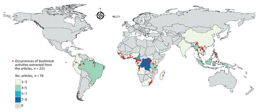
Geographic distribution of articles from the literature used to model a map of global bushmeat activities (hunting, preparing, and selling bushmeat) to improve zoonotic spillover surveillance. We extracted data from 76 articles. Red dots indicate occurrences of bushmeat activities (n = 221) in 38 countries, and colored shading indicated the number of articles extracted per country.
Results
West Africa, Southeast Asia, and Central Africa were predominantly associated with bushmeat activities. In countries such as Congo, the Democratic Republic of Congo, Gabon, the Central African Republic, and Cameroon, the availability of domestic livestock was extremely low, thus making bushmeat an important food source.
Equatorial Guinea, which houses Africa’s largest bushmeat market, is also the country with the highest proportion of bushmeat activity-associated land. Various bans to limit bushmeat sales have been futile in this region.
The emergence of zoonotic diseases such as mpox and Ebola virus disease from these Central African regions with high bushmeat activity emphasizes the importance of monitoring bushmeat activities from an epidemiological context.
Vietnam and Laos were the two southeast Asian countries with the highest association with bushmeat activities. Notably, wildlife trade between Laos, Vietnam, and China has been previously reported. Studies have previously connected the outbreak of severe acute respiratory syndrome coronavirus 1 (SARS-CoV-1) in Guangdong province with trade with Laos and Vietnam.
In the Americas, bushmeat activities were limited to hidden markets in regions around the Amazon Basin and covered 10% of the predicted area. Among the demographic and environmental covariates, deforestation, mammal richness, and precipitation had the strongest impact on model distributions.
While deforestation allows deeper access to forests and more opportunities to transport bushmeat to markets, precipitation also influences bushmeat activities. Although in some regions, the dry season increases the hunting pressure, the decrease in conservation patrols during heavy rains in other regions results in an increase in bushmeat activities.
Conclusions
The study findings suggest that the modeling of bushmeat activities could significantly improve the prediction of zoonotic disease outbreaks at a global level. Targeted surveillance of regions with high bushmeat activity could help prevent zoonotic spillovers and increase the preparedness for global zoonotic disease outbreaks.