Using detailed geographic data and open-source routing tools, researchers reveal stark regional differences in how easily Australians can reach hospitals, GPs, and pharmacies, creating a powerful new resource to study healthcare access nationwide.
Study: Travel times and distances to health services in Australia. Image Credit: BJP7images / Shutterstock
In a recent study published in the journal Scientific Data, researchers generated a national dataset describing patterns of healthcare accessibility in Australia based on road-based car travel.
Defining Geographic Healthcare Accessibility
Geographic accessibility is an important aspect of healthcare delivery, referring to the ease with which people can physically reach healthcare services. It is commonly assessed by analyzing factors such as the availability of healthcare facilities (supply), population distribution (demand), and transportation networks.
Existing Gaps in Australian Healthcare Access
A 2020 report revealed that more than 42,000 people living in inner regional, outer regional, remote, or very remote areas of Australia lacked access to any primary healthcare service within a one-hour drive. In addition, approximately 65,000 individuals lacked access to a general practice (GP) within one hour. Limited geographic access has been associated with lower healthcare utilization and poorer health outcomes.
Car-Based Modelling of Travel Time and Distance
In the present study, researchers estimated modeled driving distances and travel times to the nearest healthcare services in Australia using only car-based routing.
Health service locations were sourced from Healthdirect and included public and private hospitals, emergency departments (EDs), GPs, pharmacies, and bulk-billing GPs. Health service coordinates were indexed using k-d trees to efficiently retrieve the ten nearest candidate providers to each mesh block centroid.
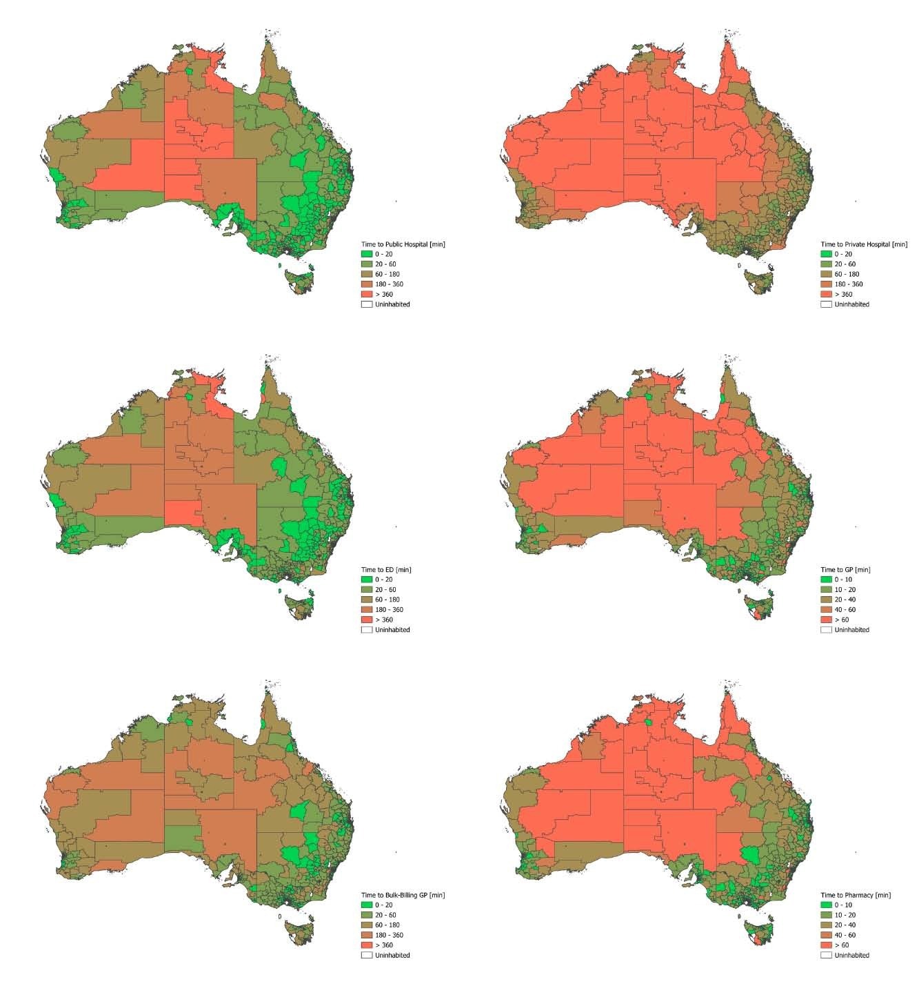
Map of Australia divided into Statistical Areas Level 2 (SA2s), color-coded based on the shortest travel time to each type of health service.Map of Australia divided into Statistical Areas Level 2 (SA2s), color-coded based on the shortest travel time to each type of health service.
Geographic Units and Population Linkage
Data on mesh blocks (MBs), the smallest geographic units defined by the Australian Bureau of Statistics (ABS), were used. Centroids were calculated using a geographic information system (GIS), specifically QGIS.
Each centroid record was linked to higher-level geographic classifications, including Statistical Area Level 1 (SA1), Statistical Area Level 2 (SA2), and the corresponding state or territory.
The dataset was further linked to population counts, postal areas, and Modified Monash Model (MMM) classifications. MMM categorizes areas by population size and remoteness, while postal areas represent ABS mesh block approximations of postcode boundaries.
Routing Infrastructure and Accessibility Metrics
OpenStreetMap data for Australia was used to initialize an Open Source Routing Machine (OSRM) server. The OSRM table service computed modeled driving distances and travel times from each mesh block centroid to the nearest private and public hospitals, GPs, EDs, bulk-billing GPs, and pharmacies.
Population-weighted mean distances and travel times to the nearest health service were then calculated for postal areas, MMM categories, and SA2 regions within each state and territory.
The higher density of pharmacies and GPs meant that most residents could access these services within a ten-minute drive. In contrast, residents of the Australian Capital Territory exhibited relatively long travel times to emergency departments and public hospitals, likely reflecting the limited number of such facilities despite the territory’s small geographic size. The Northern Territory showed relatively flat travel-time distributions, reflecting sparse health facility coverage and wide variability in travel distances.
Dataset Value and Research Applications
This study describes a nationally consistent dataset capturing car-based healthcare accessibility across Australia. The use of OSRM provided routing results comparable to commercial navigation services, although travel times may be underestimated where road routes are unavailable.
The public release of this dataset supports research into healthcare access, utilization, and outcomes, promotes methodological consistency across studies, and offers a framework that can be adapted to other countries.
 New commentary urges patient-centered AI regulation in healthcare systems